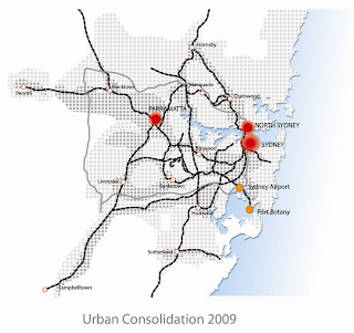


The development of Sydney can be said to be generated by different drivers throughout the different eras. It began as an agriculture settlement in Sydney Cove during 1788 and the main traffic generated was by foot and waterways with people residing near workplaces. With the introduction of the first rail system in 1855 from Sydney to Parramatta and the following tram system in 1860s, the working class people began to commute to work leaving the city slums. This has led to widening of roads along the main thoroughfare to incorporate this new infrastructure into the city fabric. After World War 2, a shift was seen from public transport to private transport when cars were introduced into the urban system leading to a different type of development. Suburbanisation came into the picture with roads radiating out of the city towards 'seachange' and 'treechange'. The first expressway, Cahill Expressway was built and not long after that tramline services was stopped and replaced by buses. The development along transport corridors led to the beginnings of satellites cities with Sydney, Parramatta and North Sydney as the main centres. Today Sydney is undergoing urban consolidation that focuses on areas with existing infrastructure and the creation of jobs and activities within these satellite cities by integrating the public transport network system and reducing the use of private cars within the city.
No comments:
Post a Comment